Thursday, October 31, 2019

Using an Amazon Kindle E-Reader


My ebook reader is from Amazon. There are lots of brands to choose from, but I like my Kindle. Here's why:
  • It's compact and light weight.
  • It's inexpensive.
  • The battery lasts a long time.
  • It holds thousands of books.
  • You can adjust the font size.
  • The contents are searchable. 
  • A dictionary is linked to the text.
  • It's readable in bright sunlight.
  • A reading light runs off the battery.
  • You can wirelessly download books.
  • There are millions of titles to choose from.
  • Amazon maintains your archived library.
  • You can buy books from the Kindle or your computer.
  • Ebooks are less expensive than print versions.
  • Many ebooks are free or low cost.
  • You can subscribe monthly to Kindle Unlimited.
  • Amazon Prime users have free Prime Reading.
  • Kindles are durable and last a long, long time!


I got mine in 2010. As you can see, she's had lots of use but she is still going strong in 2019. You can't say that for many other electronic devices.  My model is similar to the Kindle that now sells for $89.99. And the new one comes with audio capability.

http://www.powellriverbooks.comEbooks have revolutionized the publishing industry, especially for self-published authors like my husband Wayne. It's relatively easy to format and upload a manuscript for online sales. And there's no printing investment like there is for paperbacks.

I invite you to visit PowellRiverBooks.com to learn more about Wayne's series of Coastal BC Stories and science fiction titles.

If you don't have a Kindle, you can still read ebooks available from Amazon. There's are free Kindle Apps for computers, handheld devices and smart phones.

Here's a free Kindle copy of Up the Lake from Amazon.com to give it a try.

Do you have a Kindle or ebook reader? What's your favourite one and why? -- Margy

Saturday, October 26, 2019

Picnicking at Saltery Bay Provincial Park


Picnicking in the truck out of the wind.
Continuing our road trip excursions, today we drove 28 kilometres south from Powell River to enjoy fall foliage and sunshine at Saltery Bay Provincial Park.

There are two parts to the park, the Mermaid Cove Campground with 42 sites that are open from May 15 to September 15, and the day use picnic area that is open all year. It's called Mermaid Cove because of a bronze mermaid statue at 10 fathoms that is popular with scuba divers.

We stopped by a favourite restaurant south of town called Skeeter Jacks to pick up a sandwich and drinks to take with us for an impromptu picnic.

Oceanfront grass, trees and picnic tables.

The wind was blowing 25 knots so we sat in the cab of our truck while we ate. Then we took a stroll down the beach to watch the waves rolling in and enjoy the colourful fall foliage. On calmer days, there's a public boat launch available.

Clear blue skies to set off the last of the bright yellow maple leaves.

I'll leave you with this YouTube video by themarinedetective about scuba diving to see The Mermaid. Way back I was a scuba diver, but I never experienced anything this special.


It's good to remember to visit and enjoy places near home. What are some of your local favourites? -- Margy

Saturday, October 19, 2019

Day One of Lower Mainland Road Trip: Bellingham to Harrison Hot Springs BC


We've been in the States for a few weeks. With the fall foliage out, we decided to take a road trip on our way home to Powell River to enjoy the colour.


The Peace Arch at the Canada-United States border.
From Bellingham we headed north on I-5 to the Peace Arch Canadian border crossing then BC Highway 99.

I love the messages on the arch, "Children of a common mother" and "Brethren dwelling together in unity." These beliefs are so important right now.

We use Nexus cards. If you cross the border frequently, this is the way to go. Pre-screening and special lanes reduce delays.

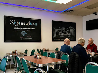
Rosie's Country Cafe in Surrey.
We made a quick stop in Surrey to take our car to the Mazda dealer.

While we waited, we had breakfast at Rosie's Country Cafe across the street. The food was great and I especially loved the crispy home-fried potatoes.

From there we headed east on 32 Avenue to Highway 15 then north to intercept Highway 1 eastbound.

This route took us through fertile farmland in the Fraser Delta and Valley regions. As Vancouver's population expands, many areas are developing, but in between you find fields of berries, potatoes, fruits and nuts, greenhouse vegetables, chickens, dairies, cattle and hogs.

Chilliwack farmland.

Highway 1 east of Abbotsford leaves the populated lower mainland. It's scenic, more like a rural road than a major highway. Here we started seeing the turning maples and oaks we were seeking. Unfortunately, the skies were gray and rain was falling.

Fall colours on a gray rainy day.

Highway 1 is the Trans-Canada Highway that starts in Victoria on Vancouver Island, uses BC Ferries to cross the Strait of Georgia, runs from Vancouver across the southern part of Canada to North Sydney in Nova Scotia, then by ferry to Newfoundland and end in St. John's.

Agassiz-Rosedale Bridge across the Fraser River.

We crossed the Fraser River on the Agassiz-Rosedale Bridge to take Highway 9 north through Agassiz to our destination, Harrison Hot Springs for a night at the resort hotel.

Harrison Hot Springs Resort Hotel and Spa.

The Village of Harrison Hot Springs and the resort are at the south end of Harrison Lake. The area is famous for it's thermal pools including several at the resort and a public pool in the center of town.

Fall colours at Harrison Hot Springs.


Old Settlers Pub within walking distance.
We arrived  at the Resort in the late afternoon and walked along the shore on our way to dinner at the Old Settler Pub. Pub food and good beer are my favourite dinner meal.

I ate here several years ago when I was on a respite getaway while caring for my mother. It was just as good as I remembered and they now have an outside heated area making dinner on a rainy day even better.

There are several accommodation options in town, but this time I wanted to try the resort.

The lake view from our room.

Our room has an expansive lake view. A wonderful way to end a busy travel day. -- Margy

Wednesday, October 16, 2019

Day Two of Lower Mainland BC Road Trip: Harrison Hot Springs to Lonsdale Quay


Day two of our Lower Mainland BC road trip took us from Harrison Hot Springs to Lonsdale Quay in North Vancouver.


Blueberry plants with bright red leaves.
We had rain, so changed our route from Highway 7 north of the Fraser River to Highway 1 south of the river to head back to Vancouver.

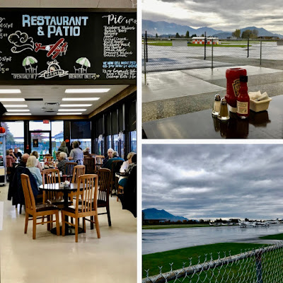
We stopped at the Chilliwack Airport Restaurant for lunch/breakfast. We landed here in our Piper Arrow 997 in the 1990s, and returned in 2008 with a Powell River Books booth at their Airshow.

We were featuring Wayne's Up the Airway book about flying and camping throughout Canada in a private plane.

Chilliwack Airport on a rainy day.

As Highway 1 comes into Vancouver, you cross the Fraser River on the Port Mann Bridge. It was reconstructed in 2012 with an amazing cable-stayed bridge.

Vancouver Port Mann Bridge.


After crossing Burrard Inlet on the Iron Workers Bridge, we exited the freeway and followed the north shore to the Lonsdale Quay Hotel.

First you pass the active docks including a huge Cargill grain storage and shipping area.

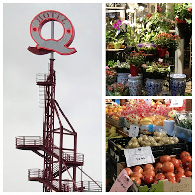
Abruptly you enter the business and residential area along the north shore. This included our destination, the Lonsdale Quay Market and Hotel.


The Lonsdale Market and Hotel.


The Tap and Barrel pub.
We relaxed in our room and visited the market.

Later we went next door to the Tap and Barrel pub for a brew and dinner. It's located in repurposed shipyard where large cranes were common for loading and unloading ships.

On the way back to the hotel, we stopped at the market for an ice cream and enjoyed the nighttime lights from distant downtown Vancouver. 

Vancouver after dark.

It was a nice way to end our Lower Mainland BC road trip. Tomorrow we head to Horseshoe Bay to catch a BC Ferry back to Powell River and Powell Lake float cabin home.

Have you been to BC's Lower Mainland? What are some of your favourite spots? -- Margy

Monday, October 14, 2019

Day Three of Lower Mainland BC Road Trip: Lonsdale to Sunshine Coast and Powell River


Day three of our Lower Mainland BC road trip took us along a route we drive frequently when we want to get from our home in Powell River to and from the big city or Bellingham.


First at the Horseshoe Bay lineup, our ferry in the distance.
We waited for the morning rush hour traffic to subside then drove from the Lonsdale Quay Hotel to catch Highway 1 northbound.

Our first stop was the Horseshoe Bay BC Ferries Terminal. We had a reservation for the 11:55 ferry going north to Langdale on the Lower Sunshine Coast.

But today it wasn't very sunny. At least the rain showers were light, making driving not too difficult.

We got a front row spot so remained in our car.

Front row on the upper deck of the Queen of Surrey.

There are comfortable seats and food service on the passenger deck. If you are parked on the enclosed lower deck you must go upstairs. If you are on the open upper deck you can remain in your car if desired. You can also walk on as a foot passenger and have an economical round trip scenic "cruise."


The first stop was the Langdale Terminal where we exited the ferry to take Highway 101 north along the Sunshine Coast. This is a beautiful drive through lush forests with glimpses of the Strait of Georgia along the way. The 84 km (52 mi) drive takes about an hour and a half.

Driving Highway 101 on the Sunshine Coast to Powell River.

Highway 101 is part of the Pan-American Highway that runs all the way to the tip of Chile.  Lund, a village 28 kilometres (17 miles) north of Powell River, claims to be Mile 0. The two lane road is good but has lots of winding curves as you near the Earls Cove Ferry Terminal.

Scenic Trout Lake is a favourite viewpoint north of Sechelt.
About a third of the way up you pass through the Village of Sechelt with full services including gas, food, lodging, camping and outdoor activities.

Other stopping points not far off the highway include: Gibsons where the popular Canadian TV series The Beachcombers was set, Roberts Creek, Halfmoon Bay, Pender Harbour and Egmont with it's impressive and dangerous Skookumchuck Narrows rapids.


Backeddy Marina is popular with locals and cruisers.
We were early for our second ferry at Earls Cove so we decided to head over to Egmont for an early dinner at the Backeddy Pub.

We've been here before by car and in our own boat.

Docking at the Backeddy Marina can be challenging for boats when the tide is running strong because Skookumchuck Narrows is just around the corner.


We got on the Island Sky for the last ferry ride home. Gray skies made photos naturally black and white. Looking up Hotham Sound on a sunny day is very different.

Comparing Hotham Sound as seen from the ferry in clouds and sun.

After a 50 minute ride we arrived at the small residential community of Saltery Bay.

Driving off the ferry at Saltery Bay.
It was originally the site of a fish salting company back in the early 20th century, hence the name. From there it's about a about 40 minute drive to Powell River.

Along the way there are several resorts, bed and breakfasts, restaurants and sporting goods establishments. There's also the ocean, forests and the expansive sky to enjoy.

I hope you enjoyed our Lower Mainland road trip and can come visit our Powell River home town sometime soon. I know you will enjoy it as much as we do. -- Margy

Thursday, October 10, 2019

Available Online: "Up the Airway" by Wayne J. Lutz


A great book for any aviation enthusiast.

Up the Airway

Coastal BC Stories
by Wayne J. Lutz


For the pilot and adventurer at heart. Fly high over beautiful Canadian lakes, forests and inlets. Land at remote strips and camp under starry skies. In addition to BC, travel to the Arctic Ocean, Hudson Bay, Canadian prairies and Pacific Northwest for a unique travel experience. Read Up the Airway by Wayne J. Lutz and see how much fun flying can be. 

Go to PowellRiverBooks.com for more information.

Kindle version for $1.99
Print version for $12.95
iPad and Ebook versions $1.99


Or check with your favourite online bookseller.

Tuesday, October 8, 2019

Whidbey Island RV Adventure Journal


Whidbey Island RV Adventure
Journal Map


In addition to my blog posts, I keep a hand written journal of our adventures. Maps help tell the story of where we went and what we saw.

Do you keep a journal? What kind do you have? How often do you write in your journal? Do you illustrate your journal or keep scrapbook items inside? -- Margy

Sunday, October 6, 2019

Whidbey Island RV Adventure: Deception Pass State Park


Reading and relaxing in the sun.
Wayne and I got our Forest River Sunseeker RV out of Gotcha Covered (our Bellingham storage location) and headed south to Whidbey Island for a new RV adventure.

It's nice having our RV all set up, ready to go at a moment's notice. All we needed to do was state the fridge and stop at Safeway to pick up fresh food for our five day, four night excursion.

To be ready for our adventure, I made reservations for two nights at Deception Pass State Park. We wanted hookups (power is available all year and water during the warmer months) so we selected Site #39 in the Forest Loop of the Cranberry Lake Campground.

For tent or dry camping, there are spots in the Lower Loop and two other park campgrounds, Bowman and Quarry Pond.

We arrived too early to go to our site, so we went to the nearby West Beach day use area to hang out in the warm sunshine.

Uncrowded West Beach on an October day.

If you aren't a registered camper, you can purchase a day use Discover Pass for $10 or an annual pass (the best deal) good at all Washington State Parks for $30.

Shore flowers and lots of driftwood.

State, county and national parks are a nice change from traditional RV parks. Many have hookups, but the setting is more natural. Site #39 was a drive through yet it had lots of privacy because of the surrounding fir, hemlock and cedar trees.

Site #39 in the Forest Loop.

Just walking around our site I found lots of interesting things to photograph.

Natural beauty in a popular Washington State Park.

The next day we walked to Cranberry Lake.


We watched fighters and submarine chaser aircraft from Naval Air Station Whidbey Island taking off and landing. This was just a hint of what was to come for the second part of our Whidbey Island RV Adventure.


Deception Pass State Park is very popular (and crowded) during the summer months, but during the shoulder season it's a perfect place to stay. -- Margy

Thursday, October 3, 2019

Whidbey Island RV Adventure: Naval Air Station Whidbey Island


There's a horeline path from the park to the base proper.
The second stop of our Whidbey Island RV adventure took us a few miles south to the Naval Air Station.

Because Wayne is retired from the Air Force, he (we) have military privileges, even on a Navy base.

I used the Department of Defense Lodging website to find information about the Cliffside RV Park. Then I called 1-877-NAVY-BED to make our reservation.


The base's Cliffside RV Park is strategically located overlooking the Strait of Juan de Fuca. We chose a waterfront site and were rewarded with #7, a spot that would be hard to get during the summer months.

Walking back towards the RV park from the base proper.

The park has level cement pads, green spaces in between, picnic tables, BBQs, fire pits, full hookups and free wifi. When Greg checked us in, he pointed out the amenities: restrooms, showers, laundry, pavilions for gatherings, a fire ring, games for adults and children, sports equipment rentals, and special activities including telescope nights for star gazing (we were sorry to miss that one).

Our Sunseeker RV parked in Site #7.

A shoreline path runs from the park to the base which has additional amenities. We walked towards the runway for closeup airplane viewing. But when they were taking off from Runway 25, we could see (and hear) all the action right from our site.

Relaxing and watching fighter jets taking off from Runway 25.

And the beach is amazing. I went beachcombing along the shore. One stone became my trip souvenir. I was the only person there on such a beautiful day.  What a luxury.

Looking north. Our RV is on the cliff behind the trees on the right,.

Here are some additional beach shots. This was the best RV park we've stayed in. It's well laid out and kept immaculate. I know we'll be back, maybe in May after we get back from our big snowbird RV adventure to California and Arizona.


If you're an authorized user for base services and don't have an RV, they have an area for tents and furnished yurts and trailers for rent. Click here for more information and pictures. - Margy

Tuesday, October 1, 2019

Available Online: "Flying the Pacific Northwest" by Wayne J. Lutz


Perfect for Pilots
and Aviation Enthusiasts of All Kinds

Flying the Pacific Northwest

by Wayne J. Lutz

Description: Airports of Western Washington and Oregon form the backdrop for adventures in the Pacific Northwest. Take the controls of a Piper Arrow, as your personal flight instructor leads you to out-of-the-way spots where recreational aircraft give us the freedom to pursue personal goals. Hints for cross-county and local flying, as presented by a 7000-hour FAA certified flight instructor. For armchair pilots and experienced pros, this book is an escape so realistic you’ll swear you’re airborne.  

Kindle $5.99
Print from Amazon.com $10.95
Check with your favourite e-book dealer 
for other formats.

Check here if you need a Kindle 
or free Kindle App.

If you enjoy the book, consider writing a review at Amazon.com
Happy reading! - Wayne